A short study in fixing Jakarta’s Traffic
An Analytical Approach to Advancing Public Transportation
By Satya Nugraha
It’s a well-documented fact that Jakarta’s traffic conditions are a major issue. A recent survey ranks Jakarta the 7th worst in the world when it comes to traffic congestion. However, addressing this challenge has not gone without notice or remedial action. Jakarta’s governor and the central government have already attempted several ways to reduce traffic congestion. One of them is the odd-even traffic policy, which attempts to reduce traffic by regulating the number of vehicles on the road in the city on any given day.
While this is commendable, it only scratches the surface of trying to solve the bigger jam. The Indonesian President, Joko Widodo, recognized this and published an executive order to create a more focused effort to improving public transportation as a long-term solution to urban mobility.
Here is a look at the actual order. Please forgive me if you do not speak Bahasa…just trust me. 😉
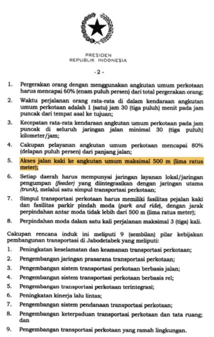
In chapter 2 “SASARAN DAN KEBIJAKAN PENYELENGGARAAN TRANSPORTASI JABODETABEK”, it says the maximum walking distance to any public transportation stop should be 500 meters.
So I began with a simple question:
What percent of the city (area) is not within this distance? (based on road distance — not just radius which would imperfectly reflect how far you would have to walk)
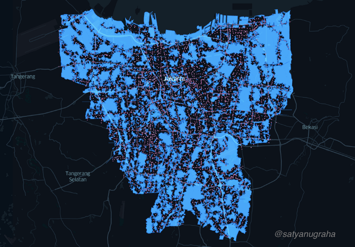
I started by collecting all current Jakarta public transportation stops including Angkot (Minivan), Minibus, Medium-sized Bus, Transjakarta and Train. There are more than 19,749 stops in total.
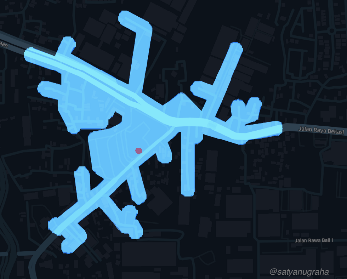
Next, I mapped out an area that is within 500 meters walking distance from each stop. For example, I simulated a 500-meter walkable path from a Transjakarta commuter stop in Kelapa Gading. The simulated path is the actual street route that has to be connected with the Transjakarta stop. The street path could be a main road or street alley (Jalan Gang).
Below is a visual depiction this analysis:
Why did I choose the road/path route instead of a radius?
A radius around a point does not predict how far a person would have to walk. Yes, it is theoretically possible that a person could reduce the walk by cutting across properties, jumping fences, running through buildings, or other methods (and of course, we’d never advise a person to do this to shorten their walk). Because radius represents a less likely scenario, I felt using actual roads would be a more accurate way to predict walking distance.
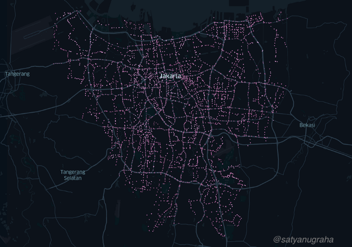
I then merged the transportation stop data with the 500-meter route data and created the following simulation. This depicts how much of the city is covered within the current public transportation ecosystem.
Cleaning Up the Final Visualisation
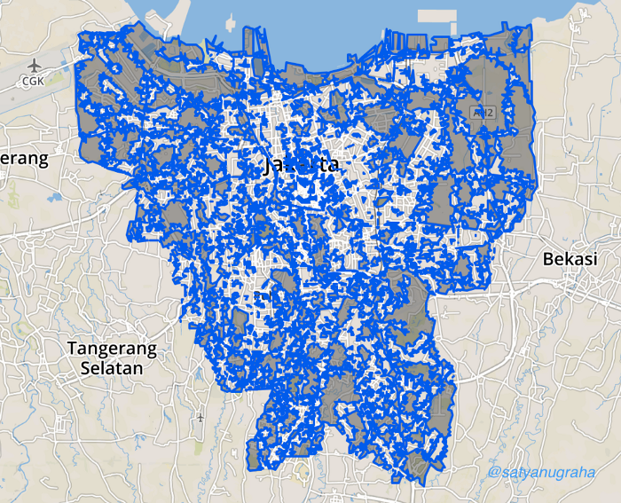
I wanted to have a better look at where the gaps were in the city. So, I widened and merged all stop locations in Jakarta and plotted them back on a map. This allowed me to better identify and differentiate between covered and uncovered areas. I then removed all public stop locations for visual cleanliness purposes. Now we can see the remaining areas that are not covered by public transportation stops.
Summary
Running some basic analytics on the data behind the map, I estimate that 45% of the area is unreachable by a public transportation stop. This represents an area covering about 300 million square meters (out of a total of 655 million square meters in the city).
One caveat: it is likely that at least part of this area would not be a place you would typically need to walk from. For example, if you are standing on a busy highway that is 600 meters from a stop, then you are technically “uncovered”. However, it is unlikely that you would ever need to walk from there (unless your car broke down or something of that nature). Hence, while I may be over-representing uncovered areas slightly, it probably isn’t far off.
In the end, the data design on this has broad applications for improving urban mobility challenges. It should also make us all aware and continue to learn and ask questions.
Follow Up Questions
Why did the executive order set the rule at “500 meters” ?
It serves as a starting point, but perhaps a better question is “what is a reasonable distance to walk?”. The consequence of setting this objective is important to consider. If 250 meters is the criteria, then the uncovered area will be substantially higher, requiring a much higher level of investment. If we set the range longer (say 750 meters), the government’s investment will be lower, but then people may not use public transportation.
Would people prefer a shorter walking distance or shorter waiting time?
Instead of investing in new stops, the solution may be additions to the public transport “fleet”. Perhaps this isn’t even a trade-off consumers think about, but shouldn’t we know before we invest billions into the system?
I’d like to credit my colleague, Raihan Saputra, for his analytical support and GO-JEK for being a company that prioritises social impact. These have been key motivators for me to explore this challenge and tackle this project. My hope is that by making our understanding of this issue more empirical and fact-based, we can improve the mobility of Jakarta residents. Please watch this space for more.
If this is interesting and you want to solve similar challenges, join us. Check out gojek.jobs for more and grab this chance to work with Southeast Asia’s first unicorn.